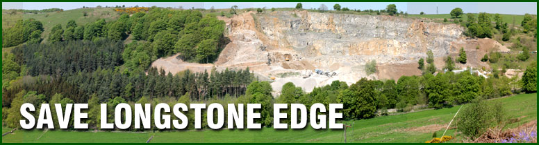

A Walk on the Edge
Dr Steve Furness
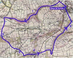
Click map to zoom in.
A very pleasant circular walk around the proposed site, so you can enjoy the best of the varied Peak District scenery and judge for yourself the likely impact of a mega-quarry.
Encompassing both limestone and gritstone scenery, this superb walk combines the intimacy of the Dales with the expansive views from the Edge. Both the scenery and wildlife reflect the fantastic diversity of geology and habitat in the area. You will pass many rarities nestling in the varied micro-habitats so please stick to the footpaths and do not pick anything.
| Distance: | 6.5 miles |
| Start: | Calver crossroads (A623, B6001, A625 junction) |
| Parking: | Usually plenty on the slip-road adjacent to the crossroads |
| Public Transport: | Many services stop at Calver including buses from Sheffield, Chesterfield and Manchester |
| Map: | OS White Peak Explorer OL 24 |
| Conditions: | Generally good underfoot but wear boots or stout shoes |
| Difficulty: | Easy with gentle ascents; descents can be slippery in wet weather |
Directions
(To open printable version click here: ![]() Word format |
Word format | ![]() PDF format)
PDF format)
- Walk along the A623 towards Stoney Middleton and after 300 yards, turn left immediately before the playing fields, through a gateway marked “Private Road”. Walk for two miles along the foot of Coombs Dale past the now disused Sallet Hole Mine. Continue until you reach a cattle grid on the left; then go through a small iron gate to the right of the grid, signposted Longstone Edge. Follow the path between two walls for 50 yards, ignoring the path to the left, and pass through a wooden gate. Go straight-ahead, keeping the wall to your left. WARNING: Avoid the hollows and nettle patches as these mark old lead mines.
- Pass through another gate, where the path is bounded by a wall and fence. At the brow of the hill rest and enjoy the panoramic views of Kinder to the north (weather permitting!). Descend to the corner of the field, and through a metal gate. About 50 yards straight ahead you will see a stile in a wire fence. To reach it, cross a dirt roadway (taking care not to get run over by the quarry lorries). Climb this stile onto an area of short grassy turf, which provides an excellent butty stop and gives superb views across the limestone plateau towards Bakewell. Now head downhill on a narrow path in a small valley. Make for the double electricity poles, keeping the wire fence on your left. On meeting a broad grassy track, turn left over the stile by a gate. Follow this track for only 75 yards then take a minor pathway signposted on the right. The path is difficult to follow across the scree but becomes better defined lower down through the bracken. At the wall climb the stile into a field. Head half left down the field to its bottom edge and through a stile, continue diagonally across the next field, through a squeeze stile and into a third field, keeping the wall on your right. On reaching the corner, cross over the stile on the right. A few yards and another squeeze stile brings you into Rowland.
- Walk 100 yards along the road to the next bend and then right through a squeeze stile. After a few yards and two more stiles, enter a field. Proceed diagonally across the field towards a gateway. Cross the next field, turning left onto the road, which takes you into Hassop.
- At the junction turn left along the main road, past (or into) the superbly camouflaged Eyre Arms and, where the main road bends left, take a minor road towards Baslow. As you pass the old school house in the hollow, the road winds up the hill. After the plantation, the road swings to the left. Take the footpath into the first grassy field on the left. Climb over another stile and into the wood. The path soon runs along a ridge, which affords excellent views of Chatsworth on the right and Backdale on the left, showing the new quarry workings. Continue through another wood down to a minor road.
- Cross the road half left into a small wooded area, which leads you back to the ridge. Pause after the next stile if you want to enjoy the superb panoramic views both up and down the Derwent Valley. The ridge ends in a beech and chestnut plantation overlooking Calver. Head downhill, bearing left onto a muddy track and, after a short distance, carefully follow the steep grassy path to the right, through the bracken. Towards the bottom of the slope, climb over a stile in the fence and go straight on towards the village. Just before the first house, go over a stile and turn right, following the wall around the house. Then bear left before turning right along a gravelled road. On reaching the metalled road, turn left and then sharp right into Cross Lane. This leads to the main road (B6001); turn right downhill and back to the traffic lights.